Geospatial Imagery Analytics Market: Snapshot
Geospatial imagery analytics is a comprehensive solution system that provides imagery, both video and image data, of the earth. The data helps companies in different sectors in taking preventive and precautionary measures. With the use of global positioning systems (GPS) and geographical information systems, geospatial imagery analytics providers collect and gather data and then provide these data to end-users. Providers of geospatial imagery analytics are investing in building their own satellites to gather the most effective earth data for end-users. The geospatial imagery analytics market is expected to expand at a CAGR of 7.0% during the forecast period of 2018-2026. In terms of revenue, the market is expected to reach US$ 8.9 Bn in 2026. The major reason for the expansion of the market is development of geographic information system (GIS) technology and convergence of geospatial information with mainstream technologies. Moreover, the rise in requirement for geospatial data from the mining and manufacturing and engineering and construction industries is also making the overall market lucrative.
The geospatial imagery analytics market is experiencing some vital trends. These trends include continuous demand for high resolution satellite images from end-user across all the major regions, as well as increased usage of location based services. Based on analytics type, the geospatial imagery analytics market can be divided into video-based and image-based. Globally, both the video-based and image-based analytics segments are expanding at a rapid pace. The use of video-based and image-based analytics is increasing across various industry verticals including defense and security and construction and manufacturing. In terms of technology, the market can be divided into geographical information systems (GIS), remote sensing, unmanned aerial vehicles (UAVS), and others. The geospatial information system (GIS) is expected to be a lucrative segment during the forecast period. Geospatial information systems (GIS) have the capability to collect and store geospatial data effectively, thereby becoming popular among defense & security, environment monitoring, and mining and manufacturing companies. Based on end-user, the market can be categorized into defense & security, government, environment monitoring, energy, utility & natural resource, engineering & construction, mining & manufacturing, insurance, agriculture, healthcare & life sciences, and others. The others segment of the market includes retail, transportation & logistics sector, etc. The defense & security and the energy, utility, & natural resources segments are prominent revenue contributors to the overall market. However, the use of geospatial imagery analytics in retail and agriculture insurance is also expected to increase in the near future. In agriculture specifically, the use of unmanned aerial vehicles for crop health monitoring and weather monitoring is widespread among farmers and farm owners.
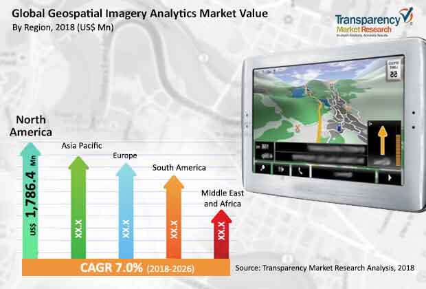
In terms of region, the geospatial imagery analytics market can be segmented into North America, Europe, South America, Middle East & Africa, and Asia Pacific. Asia Pacific, North America, and Europe are the major revenue contributors to the overall market. However, South America and Middle East & Africa are regions with high potential of the geospatial imagery analytics market.
The major strategies adopted by players operating in the market include focus on mergers and acquisitions, enhancing product portfolio, and effectively delivering the required services to end-users. The market is largely dominated by big players such as ESRI, DigitalGlobe Inc., Hexagon AB, and MDA Corporation that have been investing in research and development for a long time and have also been entering into effective mergers and acquisition for stronger penetration in the market.
The global geospatial imagery analytics market comprises a large number of multinational companies that offer a range of comprehensive services and solutions to end-users. These companies include Digital Globe, ESRI, MDA Corporation, Fugro N.V., Harris Corporation, Hexagon AB, General Electric, Planet Labs , RMSI Private Limited, Satellite Imaging Corporation, Satellite Imaging Corporation, TomTom, Trimble Navigation, Ltd. and WS Atkins Plc.
Critical Applications in Economics, Agricultural Sciences fuels Geospatial Imagery Analytics Market
Using the features of global positioning systems (GPS) and geographical information systems underpinned by robust technology, geospatial imagery analytics is an all-inclusive solution system that provides both video and image data of the Earth. The providers of geospatial imagery analytics collect and gather this data and provides it to end users. This data helps end users to take preventive and precautionary measures that could have an adverse effect on life and property.
The geospatial imagery analytics market is expanding at a rapid pace. The development of geographic information systems (GIS) and integration of geospatial information with mainstream technologies is leading to notable growth in geospatial imagery analytics market. This accounts for continued uptick in demand from the mining, construction, and manufacturing and engineering sectors. Besides this, the rising demand for high resolution satellite images from a number of end users, along with the demand for location based services is creating newer opportunities in the geospatial imagery analytics market.
Key segments of the geospatial imagery analytics market based on analytics type are video-based and image-based, both of which witness significant demand from various end users. Based on technology, unmanned aerial vehicles (UAVs), geographical information systems (GIS), remote sensing, and others are key segments of the geospatial imagery analytics market. Of them, GIS is expected to witness notable growth owing to its capability to collect and store geospatial data effectively. This accounts for the vast use of geospatial information systems in defense & security, mining, manufacturing, and environment monitoring sectors.
The geospatial imagery analytics market features an intensely competitive vendor landscape with the presence of a large number of key players. Improvement of product portfolio, effective delivery of required data, and M&As are some organic and inorganic growth strategies adopted by large players. Large investments in R&D undertaken by a handful of large companies is another ky growth strategy in the geospatial imagery analytics market.
1. Preface
1.1. Market Definition and Scope
1.2. Market Segmentation
1.3. Key Research Objectives
1.4. Research Highlights
2. Assumptions and Research Methodology
3. Executive Summary : Global Geospatial Imagery Analytics Market
4. Market Overview
4.1. Introduction
4.2. Market Dynamics
4.2.1. Drivers
4.2.2. Restraints
4.2.3. Opportunities
4.3. Key Trends Analysis
4.4. Global Geospatial Imagery Analytics Market Analysis and Forecast, 2016–2026
4.4.1. Market Revenue Projections (US$ Mn)
4.5. Porter’s Five Forces Analysis - Global Geospatial Imagery Analytics Market
4.6. Ecosystem Analysis - Global Geospatial Imagery Analytics Market
4.7. Market Outlook
5. Global Geospatial Imagery Analytics Market Analysis and Forecast, By Technology
5.1. Overview and Definitions
5.2. Geospatial Imagery Analytics Market Size (US$ Mn) Forecast, by Technology, 2016–2026
5.2.1. Global Positioning Systems (GPS)
5.2.2. Geographical Information Systems (GIS)
5.2.3. Remote Sensing
5.2.4. Unmanned Aerial Vehicles (UAVS)
5.2.5. Others
5.3. Market Attractiveness, by Technology
6. Global Geospatial Imagery Analytics Market Analysis and Forecast, By Analytics Type
6.1. Overview and Definitions
6.2. Geospatial Imagery Analytics Market Size (US$ Mn) Forecast, by Analytics Type, 2016–2026
6.2.1. Video-based
6.2.2. Image-based
6.3. Market Attractiveness, by Analytics Type
7. Global Geospatial Imagery Analytics Market Analysis and Forecast, By Deployment
7.1. Overview and Definitions
7.2. Geospatial Imagery Analytics Market Size (US$ Mn) Forecast, by Deployment, 2016–2026
7.2.1. On-premise
7.2.2. Cloud
7.3. Market Attractiveness, by Deployment
8. Global Geospatial Imagery Analytics Market Analysis and Forecast, By Application
8.1. Overview and Definitions
8.2. Geospatial Imagery Analytics Market Size (US$ Mn) Forecast, by Application, 2016–2026
8.2.1. Defense & Security
8.2.2. Government
8.2.3. Environment Monitoring
8.2.4. Energy, Utility & Natural Resources
8.2.5. Engineering & Construction
8.2.6. Mining & Manufacturing
8.2.7. Insurance
8.2.8. Agriculture
8.2.9. Healthcare & Life Sciences
8.2.10. Others
8.3. Market Attractiveness, by Application
9. Global Geospatial Imagery Analytics Market Analysis and Forecast, by Region
9.1. Key Findings
9.2. Geospatial Imagery Analytics Market Size (US$ Mn) Forecast, by Region, 2016–2026
9.2.1. North America
9.2.2. Europe
9.2.3. Asia Pacific
9.2.4. Middle East and Africa
9.2.5. South America
9.3. Market Attractiveness, by Region
10. North America Geospatial Imagery Analytics Market Analysis and Forecast
10.1. Overview
10.2. Geospatial Imagery Analytics Market Size (US$ Mn) Forecast, by Technology, 2016–2026
10.2.1. Global Positioning Systems (GPS)
10.2.2. Geographical Information Systems (GIS)
10.2.3. Remote Sensing
10.2.4. Unmanned Aerial Vehicles (UAVS)
10.2.5. Others
10.3. Geospatial Imagery Analytics Market Size (US$ Mn) Forecast, by Analytics Type, 2016–2026
10.3.1. Video-based
10.3.2. Image-based
10.4. Geospatial Imagery Analytics Market Size (US$ Mn) Forecast, by Deployment, 2016–2026
10.4.1. On-premise
10.4.2. Cloud
10.5. Geospatial Imagery Analytics Market Size (US$ Mn) Forecast, by Application, 2016–2026
10.5.1. Defense & Security
10.5.2. Government
10.5.3. Environment Monitoring
10.5.4. Energy, Utility & Natural Resources
10.5.5. Engineering & Construction
10.5.6. Mining & Manufacturing
10.5.7. Insurance
10.5.8. Agriculture
10.5.9. Healthcare & Life Sciences
10.5.10. Others
10.6. Geospatial Imagery Analytics Market Size (US$ Mn) Forecast, by Country, 2016–2026
10.6.1. The U.S.
10.6.2. Canada
10.6.3. Rest of North America
10.7. Market Attractiveness Analysis
10.7.1. By Technology
10.7.2. By Analytics Type
10.7.3. By Deployment
10.7.4. By Application
10.7.5. By Country
11. Europe Geospatial Imagery Analytics Market Analysis and Forecast
11.1. Overview
11.2. Geospatial Imagery Analytics Market Size (US$ Mn) Forecast, by Technology, 2016–2026
11.2.1. Global Positioning Systems (GPS)
11.2.2. Geographical Information Systems (GIS)
11.2.3. Remote Sensing
11.2.4. Unmanned Aerial Vehicles (UAVS)
11.2.5. Others
11.3. Geospatial Imagery Analytics Market Size (US$ Mn) Forecast, by Analytics Type, 2016–2026
11.3.1. Video-based
11.3.2. Image-based
11.4. Geospatial Imagery Analytics Market Size (US$ Mn) Forecast, by Deployment, 2016–2026
11.4.1. On-premise
11.4.2. Cloud
11.5. Geospatial Imagery Analytics Market Size (US$ Mn) Forecast, by Application, 2016–2026
11.5.1. Defense & Security
11.5.2. Government
11.5.3. Environment Monitoring
11.5.4. Energy, Utility & Natural Resources
11.5.5. Engineering & Construction
11.5.6. Mining & Manufacturing
11.5.7. Insurance
11.5.8. Agriculture
11.5.9. Healthcare & Life Sciences
11.5.10. Others
11.6. Geospatial Imagery Analytics Market Size (US$ Mn) Forecast, by Country, 2016–2026
11.6.1. Germany
11.6.2. France
11.6.3. U.K.
11.6.4. Rest of Europe
11.7. Market Attractiveness Analysis
11.7.1. By Technology
11.7.2. By Analytics Type
11.7.3. By Deployment
11.7.4. By Application
11.7.5. By Country
12. Asia Pacific Geospatial Imagery Analytics Market Analysis and Forecast
12.1. Overview
12.2. Geospatial Imagery Analytics Market Size (US$ Mn) Forecast, by Technology, 2016–2026
12.2.1. Global Positioning Systems (GPS)
12.2.2. Geographical Information Systems (GIS)
12.2.3. Remote Sensing
12.2.4. Unmanned Aerial Vehicles (UAVS)
12.2.5. Others
12.3. Geospatial Imagery Analytics Market Size (US$ Mn) Forecast, by Analytics Type, 2016–2026
12.3.1. Video-based
12.3.2. Image-based
12.4. Geospatial Imagery Analytics Market Size (US$ Mn) Forecast, by Deployment, 2016–2026
12.4.1. On-premise
12.4.2. Cloud
12.5. Geospatial Imagery Analytics Market Size (US$ Mn) Forecast, by Application, 2016–2026
12.5.1. Defense & Security
12.5.2. Government
12.5.3. Environment Monitoring
12.5.4. Energy, Utility & Natural Resources
12.5.5. Engineering & Construction
12.5.6. Mining & Manufacturing
12.5.7. Insurance
12.5.8. Agriculture
12.5.9. Healthcare & Life Sciences
12.5.10. Others
12.6. Geospatial Imagery Analytics Market Size (US$ Mn) Forecast, by Country, 2016–2026
12.6.1. China
12.6.2. Japan
12.6.3. India
12.6.4. Rest of Asia Pacific
12.7. Market Attractiveness Analysis
12.7.1. By Technology
12.7.2. By Analytics Type
12.7.3. By Deployment
12.7.4. By Application
12.7.5. By Country
13. Middle East and Africa (MEA) Geospatial Imagery Analytics Market Analysis and Forecast
13.1. Overview
13.2. Geospatial Imagery Analytics Market Size (US$ Mn) Forecast, by Technology, 2016–2026
13.2.1. Global Positioning Systems (GPS)
13.2.2. Geographical Information Systems (GIS)
13.2.3. Remote Sensing
13.2.4. Unmanned Aerial Vehicles (UAVS)
13.2.5. Others
13.3. Geospatial Imagery Analytics Market Size (US$ Mn) Forecast, by Analytics Type, 2016–2026
13.3.1. Video-based
13.3.2. Image-based
13.4. Geospatial Imagery Analytics Market Size (US$ Mn) Forecast, by Deployment, 2016–2026
13.4.1. On-premise
13.4.2. Cloud
13.5. Geospatial Imagery Analytics Market Size (US$ Mn) Forecast, by Application, 2016–2026
13.5.1. Defense & Security
13.5.2. Government
13.5.3. Environment Monitoring
13.5.4. Energy, Utility & Natural Resources
13.5.5. Engineering & Construction
13.5.6. Mining & Manufacturing
13.5.7. Insurance
13.5.8. Agriculture
13.5.9. Healthcare & Life Sciences
13.5.10. Others
13.6. Geospatial Imagery Analytics Market Size (US$ Mn) Forecast, by Country, 2016–2026
13.6.1. GCC Countries
13.6.2. South Africa
13.6.3. Rest of MEA
13.7. Market Attractiveness Analysis
13.7.1. By Technology
13.7.2. By Analytics Type
13.7.3. By Deployment
13.7.4. By Application
13.7.5. By Country
14. South America Geospatial Imagery Analytics Market Analysis and Forecast
14.1. Overview
14.2. Geospatial Imagery Analytics Market Size (US$ Mn) Forecast, by Technology, 2016–2026
14.2.1. Global Positioning Systems (GPS)
14.2.2. Geographical Information Systems (GIS)
14.2.3. Remote Sensing
14.2.4. Unmanned Aerial Vehicles (UAVS)
14.2.5. Others
14.3. Geospatial Imagery Analytics Market Size (US$ Mn) Forecast, by Analytics Type, 2016–2026
14.3.1. Video-based
14.3.2. Image-based
14.4. Geospatial Imagery Analytics Market Size (US$ Mn) Forecast, by Deployment, 2016–2026
14.4.1. On-premise
14.4.2. Cloud
14.5. Geospatial Imagery Analytics Market Size (US$ Mn) Forecast, by Application, 2016–2026
14.5.1. Defense & Security
14.5.2. Government
14.5.3. Environment Monitoring
14.5.4. Energy, Utility & Natural Resources
14.5.5. Engineering & Construction
14.5.6. Mining & Manufacturing
14.5.7. Insurance
14.5.8. Agriculture
14.5.9. Healthcare & Life Sciences
14.5.10. Others
14.6. Geospatial Imagery Analytics Market Size (US$ Mn) Forecast, by Country, 2016–2026
14.6.1. Brazil
14.6.2. Rest of South America
14.7. Market Attractiveness Analysis
14.7.1. By Technology
14.7.2. By Analytics Type
14.7.3. By Deployment
14.7.4. By Application
14.7.5. By Country
15. Competition Landscape
15.1. Market Share Analysis, by Company (2017)
15.2. Company Profiles (Details – Overview, Financials, Recent Developments and Strategy)
15.2.1. Digital Globe
15.2.1.1. Company Details
15.2.1.2. Company Description
15.2.1.3. SWOT
15.2.1.4. Strategy
15.2.2. ESRI, MDA Corporation
15.2.2.1. Company Details
15.2.2.2. Company Description
15.2.2.3. SWOT
15.2.2.4. Strategy
15.2.3. Fugro N.V.
15.2.3.1. Company Details
15.2.3.2. Company Description
15.2.3.3. SWOT
15.2.3.4. Strategy
15.2.4. Harris Corporation
15.2.4.1. Company Details
15.2.4.2. Company Description
15.2.4.3. SWOT
15.2.4.4. Strategy
15.2.5. Hexagon AB
15.2.5.1. Company Details
15.2.5.2. Company Description
15.2.5.3. SWOT
15.2.5.4. Strategy
15.2.6. General Electric
15.2.6.1. Company Details
15.2.6.2. Company Description
15.2.6.3. SWOT
15.2.6.4. Strategy
15.2.7. Planet Labs
15.2.7.1. Company Details
15.2.7.2. Company Description
15.2.7.3. SWOT
15.2.7.4. Strategy
15.2.8. RMSI Private Limited
15.2.8.1. Company Details
15.2.8.2. Company Description
15.2.8.3. SWOT
15.2.8.4. Strategy
15.2.9. Satellite Imaging Corporation
15.2.9.1. Company Details
15.2.9.2. Company Description
15.2.9.3. SWOT
15.2.9.4. Strategy
15.2.10. TomTom
15.2.10.1. Company Details
15.2.10.2. Company Description
15.2.10.3. SWOT
15.2.10.4.Strategy
15.2.11. Trimble Navigation, Ltd.
15.2.11.1.Company Details
15.2.11.2. Company Description
15.2.11.3. SWOT
15.2.11.4. Strategy
15.2.12. WS Atkins Plc.
15.2.12.1.Company Details
15.2.12.2. Company Description
15.2.12.3. SWOT
15.2.12.4. Strategy
16. Key Takeaways
List of Table
Table 1: Global Geospatial Imagery Analytics Market Revenue (US$ Mn) Forecast, by Technology, 2016–2026
Table 2: Global Geospatial Imagery Analytics Market Revenue (US$ Mn) Forecast, by Analytics Type, 2016–2026
Table 3: Global Geospatial Imagery Analytics Market Revenue (US$ Mn) Forecast, by Deployment, 2016–2026
Table 4: Global Geospatial Imagery Analytics Market Revenue (US$ Mn) Forecast, by End-use, 2016–2026
Table 5: Global Geospatial Imagery Analytics Market Revenue (US$ Mn) Forecast, by Region, 2016–2026
Table 6: North America Geospatial Imagery Analytics Market Revenue (US$ Mn) Forecast, by Analytics Type, 2016–2026
Table 7: North America Geospatial Imagery Analytics Market Revenue (US$ Mn) Forecast, by Technology, 2016–2026
Table 8: North America Geospatial Imagery Analytics Market Revenue (US$ Mn) Forecast, by Deployment, 2016–2026
Table 9: North America Geospatial Imagery Analytics Market Revenue (US$ Mn) Forecast, by End-use, 2016–2026
Table 10: North America Geospatial Imagery Analytics Market Revenue (US$ Mn) Forecast, by Country, 2016–2026
Table 11: Europe Geospatial Imagery Analytics Market Revenue (US$ Mn) Forecast, by Analytics Type, 2016–2026
Table 12: Europe Geospatial Imagery Analytics Market Revenue (US$ Mn) Forecast, by Technology, 2016–2026
Table 13: Europe Geospatial Imagery Analytics Market Revenue (US$ Mn) Forecast, by Deployment, 2016–2026
Table 14: Europe Geospatial Imagery Analytics Market Revenue (US$ Mn) Forecast, by End-use, 2016–2026
Table 15: Europe Geospatial Imagery Analytics Market Revenue (US$ Mn) Forecast, by Country, 2016–2026
Table 16: Asia Pacific Geospatial Imagery Analytics Market Revenue (US$ Mn) Forecast, by Analytics Type, 2016–2026
Table 17: Asia Pacific Geospatial Imagery Analytics Market Revenue (US$ Mn) Forecast, by Technology, 2016–2026
Table 18: Asia Pacific Geospatial Imagery Analytics Market Revenue (US$ Mn) Forecast, by Deployment, 2016–2026
Table 19: Asia Pacific Geospatial Imagery Analytics Market Revenue (US$ Mn) Forecast, by End-use, 2016–2026
Table 20: Asia Pacific Geospatial Imagery Analytics Market Revenue (US$ Mn) Forecast, by Country, 2016–2026
Table 21: MEA Geospatial Imagery Analytics Market Revenue (US$ Mn) Forecast, by Analytics Type, 2016–2026
Table 22: MEA Geospatial Imagery Analytics Market Revenue (US$ Mn) Forecast, by Technology, 2016–2026
Table 23: MEA Geospatial Imagery Analytics Market Revenue (US$ Mn) Forecast, by Deployment, 2016–2026
Table 24: MEA Geospatial Imagery Analytics Market Revenue (US$ Mn) Forecast, by End-use, 2016–2026
Table 25: MEA Geospatial Imagery Analytics Market Revenue (US$ Mn) Forecast, by Country, 2016–2026
Table 26 : South America Geospatial Imagery Analytics Market Revenue (US$ Mn) Forecast, by Analytics Type, 2016–2026
Table 27: South America Geospatial Imagery Analytics Market Revenue (US$ Mn) Forecast, by Technology, 2016–2026
Table 28: South America Geospatial Imagery Analytics Market Revenue (US$ Mn) Forecast, by Deployment, 2016–2026
Table 29: South America Geospatial Imagery Analytics Market Revenue (US$ Mn) Forecast, by End-use, 2016–2026
Table 30: South America Geospatial Imagery Analytics Market Revenue (US$ Mn) Forecast, by Country, 2016–2026
List of Figures
Figure 1: The Global Geospatial Imagery Analytics Market Overview
Figure 2: Geospatial Imagery Analytics Market Size (US$ Mn) Forecast, 2016 – 2026
Figure 3: Global Geospatial Imagery Analytics Market Y-o-Y Growth (Value %) Forecast, 2017 – 2026
Figure 4: Global Geospatial Imagery Analytics Market Opportunity Growth Analysis (US$ Mn), 2016 – 2026
Figure 5: Porters Five Forces Analysis
Figure 6: Ecosystem analysis
Figure 7: Market Outlook, by Analytics Type
Figure 8: Market Outlook, by Deployment Type
Figure 8: Market Outlook, by Technology
Figure 8: Market Outlook, By technology
Figure 9: Global Geospatial Imagery Analytics Market Share Analysis, by Technology (2018)
Figure 10: Global Geospatial Imagery Analytics Market Share Analysis, by Technology (2026)
Figure 11: Geospatial Imagery Analytics Market Attractiveness Analysis, by Technology, 2018
Figure 12: Global Geospatial Imagery Analytics Market Value Share, by Analytics Type (2018)
Figure 13: Global Geospatial Imagery Analytics Market Value Share, by Analytics Type (2026)
Figure 14 : Global Geospatial Imagery Analytics Market Attractiveness Analysis, by Analytics Type, 2018
Figure 15 : Global Geospatial Imagery Analytics Market Share Analysis, by Deployment (2018)
Figure 16 : Global Geospatial Imagery Analytics Market Share Analysis, by Deployment (2026)
Figure 17 : Geospatial Imagery Analytics Market Attractiveness Analysis, by Deployment, 2018
Figure 18 : Global Geospatial Imagery Analytics Market Share Analysis, by End–use (2018)
Figure 19 : Global Geospatial Imagery Analytics Market Share Analysis, by End-use (2026)
Figure 20 : Geospatial Imagery Analytics Market Attractiveness Analysis, by End-use, 2018
Figure 21 : Global Geospatial Imagery Analytics Market Share Analysis, by Region (2018)
Figure 22 : Global Geospatial Imagery Analytics Market Share Analysis, by Region (2026)
Figure 23 : Global Geospatial Imagery Analytics Market Attractiveness Analysis, by Region, 2018
Figure 24: North America Geospatial Imagery Analytics Market Revenue (US$ Mn) and Y-o-Y Forecast, 2018– 2026
Figure 25: North America Geospatial Imagery Analytics Opportunity Growth Analysis (US$ Mn) Forecast, 2016 – 2026
Figure 26: North America Geospatial Imagery Analytics Market Value Share, by Analytics Type (2018)
Figure 27 : North America Geospatial Imagery Analytics Market Value Share, by Analytics Type (2026)
Figure 28: North America Geospatial Imagery Analytics Market Share Analysis, by Technology (2018)
Figure 29 : North America Geospatial Imagery Analytics Market Share Analysis, by Technology (2026)
Figure 30: North America Geospatial Imagery Analytics Market Share Analysis, by Deployment (2018)
Figure 31 : North America Geospatial Imagery Analytics Market Share Analysis, by Deployment (2026)
Figure 32 : North America Geospatial Imagery Analytics Market Share Analysis, by End–use (2018)
Figure 33 : North America Geospatial Imagery Analytics Market Share Analysis, by End-use (2026)
Figure 34: North America Geospatial Imagery Analytics Market Share Analysis, by Country (2018)
Figure 35: North America Geospatial Imagery Analytics Market Share Analysis, by Country (2026)
Figure 36 : North America Geospatial Imagery Analytics Market Attractiveness Analysis, by Analytics Type, 2018
Figure 37 : North America Geospatial Imagery Analytics Market Attractiveness Analysis, by Technology, 2018
Figure 38: North America Geospatial Imagery Analytics Market Attractiveness Analysis, by Deployment, 2018
Figure 39 : North America Geospatial Imagery Analytics Market Attractiveness Analysis, by Country, 2018
Figure 40 : Geospatial Imagery Analytics Market Attractiveness Analysis, by End-use, 2018
Figure 41 : Europe Geospatial Imagery Analytics Market Revenue (US$ Mn) and Y-o-Y Forecast, 2018– 2026
Figure 42 : Europe Geospatial Imagery Analytics Opportunity Growth Analysis (US$ Mn) Forecast, 2016 – 2026
Figure 43 : Europe Geospatial Imagery Analytics Market Value Share, by Analytics Type (2018)
Figure 44 : Europe Geospatial Imagery Analytics Market Value Share, by Analytics Type (2026)
Figure 45 : Europe Geospatial Imagery Analytics Market Share Analysis, by Technology (2018)
Figure 46: Europe Geospatial Imagery Analytics Market Share Analysis, by Technology (2026)
Figure 47: Europe Geospatial Imagery Analytics Market Share Analysis, by Deployment (2018)
Figure 48 : Europe Geospatial Imagery Analytics Market Share Analysis, by Deployment (2026)
Figure 49: Europe Geospatial Imagery Analytics Market Share Analysis, by End – use (2018)
Figure 50 : Europe Geospatial Imagery Analytics Market Share Analysis, by End - use (2026)
Figure 51 : Europe Geospatial Imagery Analytics Market Share Analysis, by Country (2018)
Figure 52 : Europe Geospatial Imagery Analytics Market Share Analysis, by Country (2026)
Figure 53 : Europe Geospatial Imagery Analytics Market Attractiveness Analysis, by Analytics Type, 2018
Figure 54 : Europe Geospatial Imagery Analytics Market Attractiveness Analysis, by Technology, 2018
Figure 55 : Europe Geospatial Imagery Analytics Market Attractiveness Analysis, by Deployment, 2018
Figure 56 : Europe Geospatial Imagery Analytics Market Attractiveness Analysis, by Country, 2018
Figure 57: Geospatial Imagery Analytics Market Attractiveness Analysis, by End-use, 2018
Figure 58 : Asia Pacific Geospatial Imagery Analytics Market Revenue (US$ Mn) and Y-o-Y Forecast, 2018– 2026
Figure 59 : Asia Pacific Geospatial Imagery Analytics Opportunity Growth Analysis (US$ Mn) Forecast, 2016 – 2026
Figure 60 : Asia Pacific Geospatial Imagery Analytics Market Value Share, by Analytics Type (2018)
Figure 61 : Asia Pacific Geospatial Imagery Analytics Market Value Share, by Analytics Type (2026)
Figure 62 : Asia Pacific Geospatial Imagery Analytics Market Share Analysis, by Technology (2018)
Figure 63 : Asia Pacific Geospatial Imagery Analytics Market Share Analysis, by Technology (2026)
Figure 64 : Asia Pacific Geospatial Imagery Analytics Market Share Analysis, by Deployment (2018)
Figure 65 : Asia Pacific Geospatial Imagery Analytics Market Share Analysis, By Deployment (2026)
Figure 66 : Asia Pacific Geospatial Imagery Analytics Market Share Analysis, by End-use (2018)
Figure 67 : Asia Pacific Geospatial Imagery Analytics Market Share Analysis, by End-use (2026)
Figure 68 : Asia Pacific Geospatial Imagery Analytics Market Share Analysis, by Country (2018)
Figure 69 : Asia Pacific Geospatial Imagery Analytics Market Share Analysis, by Country (2026)
Figure 70 : Asia Pacific Geospatial Imagery Analytics Market Attractiveness Analysis, by Analytics Type, 2018
Figure 71 : Asia Pacific Geospatial Imagery Analytics Market Attractiveness Analysis, by Technology, 2018
Figure 72 : Asia Pacific Geospatial Imagery Analytics Market Attractiveness Analysis, by Deployment, 2018
Figure 73 : Asia Pacific Geospatial Imagery Analytics Market Attractiveness Analysis, by Country, 2018
Figure 74: Geospatial Imagery Analytics Market Attractiveness Analysis, by End-use, 2018
Figure 75 : MEA Geospatial Imagery Analytics Market Revenue (US$ Mn) and Y-o-Y Forecast, 2017 – 2026
Figure 76 : MEA Geospatial Imagery Analytics Opportunity Growth Analysis (US$ Mn) Forecast, 2017 – 2026
Figure77 : MEA Geospatial Imagery Analytics Market Value Share, by Analytics Type (2018)
Figure 78 : MEA Geospatial Imagery Analytics Market Value Share, by Analytics Type (2026)
Figure 79 : MEA Geospatial Imagery Analytics Market Share Analysis, by Technology (2018)
Figure 80 : MEA Geospatial Imagery Analytics Market Share Analysis, by Technology (2026)
Figure 81 : MEA Geospatial Imagery Analytics Market Share Analysis, by Deployment (2018)
Figure 82 : MEA Geospatial Imagery Analytics Market Share Analysis, by Deployment (2026)
Figure 83: MEA Geospatial Imagery Analytics Market Share Analysis, by End–use (2018)
Figure 84 : MEA Geospatial Imagery Analytics Market Share Analysis, by End-use (2026)
Figure 85 : MEA Geospatial Imagery Analytics Market Share Analysis, by Country (2018)
Figure 86 : MEA Geospatial Imagery Analytics Market Share Analysis, by Country (2026)
Figure 87 : MEA Geospatial Imagery Analytics Market Attractiveness Analysis, by Analytics Type, 2018
Figure 88 : MEA Geospatial Imagery Analytics Market Attractiveness Analysis, by Technology, 2018
Figure 89 : MEA Geospatial Imagery Analytics Market Attractiveness Analysis, by Deployment, 2018
Figure 90 : MEA Geospatial Imagery Analytics Market Attractiveness Analysis, by Country, 2018
Figure 91 : Geospatial Imagery Analytics Market Attractiveness Analysis, by End-use, 2018
Figure 92 : South America Geospatial Imagery Analytics Market Revenue (US$ Mn) and Y-o-Y Forecast, 2018– 2026
Figure 93 : South America Geospatial Imagery Analytics Opportunity Growth Analysis (US$ Mn) Forecast, 2016 – 2026
Figure 94 : South America Geospatial Imagery Analytics Market Value Share, by Analytics Type (2018)
Figure 95 : South America Geospatial Imagery Analytics Market Value Share, by Analytics Type (2026)
Figure 96 : South America Geospatial Imagery Analytics Market Share Analysis, by Technology (2018)
Figure 97 : South America Geospatial Imagery Analytics Market Share Analysis, by Technology (2026)
Figure 98 : South America Geospatial Imagery Analytics Market Share Analysis, by Deployment (2018)
Figure 99 : South America Geospatial Imagery Analytics Market Share Analysis, by Deployment (2026)
Figure 100 : South America Geospatial Imagery Analytics Market Share Analysis, by End–use (2018)
Figure 101 : South America Geospatial Imagery Analytics Market Share Analysis, by End-use (2026)
Figure 102 : South America Geospatial Imagery Analytics Market Share Analysis, by Country (2018)
Figure 103 : South America Geospatial Imagery Analytics Market Share Analysis, by Country (2026)
Figure 104 : South America Geospatial Imagery Analytics Market Attractiveness Analysis, by Analytics Type, 2018
Figure 105 : South America Geospatial Imagery Analytics Market Attractiveness Analysis, by Technology, 2018
Figure 106 : South America Geospatial Imagery Analytics Market Attractiveness Analysis, by Deployment, 2018
Figure 107 : South America Geospatial Imagery Analytics Market Attractiveness Analysis, by Country, 2018
Figure 108 : Geospatial Imagery Analytics Market Attractiveness Analysis, by End-use, 2018
Figure 109 : Market Share Analysis, 2017 (Value %)
Copyright © Transparency Market Research, Inc. All Rights reserved
Trust Online

Geospatial Imagery Analytics Market
